- F1
- Αρχείο
- January 1, 2015 - December 31, 2016
Example fonds Scope and content (ISAD 3.3.1)
8931 αποτελέσματα με ψηφιακά αντικείμενα Προβολή αποτελεσμάτων με ψηφιακά αντικείμενα
Example fonds Scope and content (ISAD 3.3.1)
These maps were commissioned to Dario Ingiusto for the purpose of the Open Jerusalem project. They represent Jerusalem at different stages of its evolution, from 1187 to 1967.
Dario Ingiusto (DI)
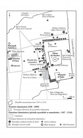
Map representing the Islamic foundations in Jerusalem at the Ayyubid and Mamluk periods, 1187-1516
Μέρος τουDario Ingiusto's records
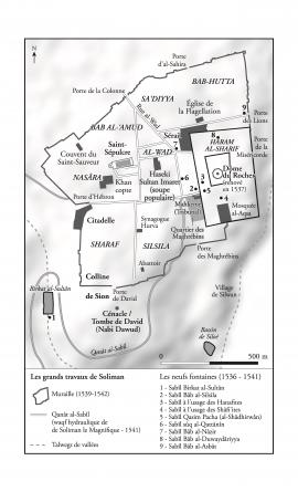
Map representing Jerusalem at the Ottoman period, 1516-1917
Μέρος τουDario Ingiusto's records
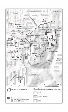
Map representing Jerusalem in the early 1930's
Μέρος τουDario Ingiusto's records
These documents are part of the records created by Vincent Lemire during his historical research on the Mughrabi quarter.
They mainly consist in photographs of objects which were found by archeologists on excavation sites and which are kept by the Israel Antiquity Authority (IAA). There are also a photograph of the Western Wall Plaza and an extract from his research notebook.
Vincent Lemire (VL)

Photograph of the Western Wall Plaza
Μέρος τουVincent Lemire's records

View of the excavation of Beit Haliba
Μέρος τουPublications and Printed Documents
Photograph publicated in : Emek Shaveh, “Beit Haliba” and the Givati Parking Lot Archeological Excavations and their Effect on the Status Quo in the Old City of Jerusalem and in Silwan", September 9, 2013: https://emekshaveh.org/en/haliba/
Μέρος τουArchives of organizations and bodies preserved by the Central Zionist Archives
Not scanned
Μέρος τουArchives of organizations and bodies preserved by the Central Zionist Archives
Not scanned