- US-LoC/LC-M32-15104
- Item
- [ca 1920]
Part of The Matson Photograph (G. Eric and Edith) Collection
72 results directly related Exclude narrower terms
Part of The Matson Photograph (G. Eric and Edith) Collection

Part of The Matson Photograph (G. Eric and Edith) Collection
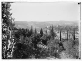
View of the Maghreb district to the east, early 1930s

List of the 135 houses destroyed in the mughrabi quarter
Part of International Committee of the Red Cross, General Departments
List established by Aref el-Aref in June 1967 and forwarded to the ICRC in July 1969.

Palestine Riots. Dossier for Chief Secretary
Part of Sir Harry Luke Collection
official telegrams, reports, memoranda and press resumés. 17 Aug.-8 Sept. 1929.
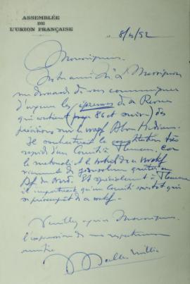
Letter from Jean Scelles-Millie to Monsignor Duval, Archbishop of Algiers
Issue of the "Revue des Études Islamiques" (REI), vol. XIX, 1951
This issue includes an article by Louis Massignon with maps selected for the Archival City project:
ouis Massignon, "Documents sur certains waqfs des lieux saints de l'Islam : Principalement sur le waqf Tamini à Hébron et sur le waqf Hancénien Abu Madyan à Jérusalem", Revue des Études Islamiques, vol. XIX, 1951, p. 73-120.

Sheet XVII, in: Map of Western Palestine in 26 sheets from the surveys conducted for the Committee of the Palestine Exploration Fund [cartographic material] / by Lieutenants C.R. Conder and H.H. Kitchener R.E. during the years 1872-1877, [maps drawn in May 1878], London, Photozincographed and Printed for the Committee of the Palestine Exploration Fund at the Ordnance Survey Office Southampton, 1880.
In particular, this sheet shows Jerusalem and its surroundings.
A copy of this map is preserved in the Laor Collection at the National Library of Israel and its digitalization is available online (accessed 2022-01-21): https://www.nli.org.il/en/maps/NNL_MAPS_JER002368494/NLI#$FL50537899
Claude Reignier Conder (CRC)
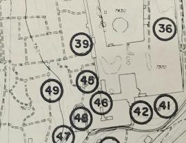
Jerusalem Jordan regional planning proposals
This document consists in 2 maps.
A copy of this document is preserved at the National Library of Israel and its description is available online (accessed 2023-05-05): https://www.nli.org.il/en/maps/NNL_MAPS_JER990023670330205171/NLI
Henry Kendall (HK)
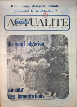
Algérie Actualité, n° 87, June 18, 1967
Newspaper issue: Algérie Actualité, n° 87, June 18, 1967.
Issue mentioned in: Vincent Lemire, "Au pied du mur : Vie et mort du quartier maghrébin de Jérusalem (1187-1967)", Paris, Éditions du Seuil, coll. "L'univers historique", 2022, p. 254-255.
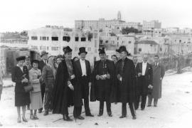
Photograph of a group of people in the no man's land of Jerusalem, in 1949
Part of EBAF's Photographic Collection
This photograph was taken in the no man's land, between the French consulate and the Jaffa Gate.
René Neuville, French Consul General, is among the four men at the front of the picture, on the left side.