Showing 11 results

Archival description
Publications and Printed Documents With digital objects
Print preview View:

General Plan of Jerusalem

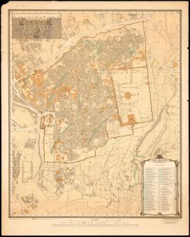
General Plan of Jerusalem, in "Palestine and Syria: Handbook for Travellers", Leipsic, Karl Baedeker, 1894 [first edition: 1876], unnumbered pages between p. 18 and p. 19.

A copy of this travel guide is preserved at the Rose Library (MARBL - USA) and its digitalization is available online (accessed 2022-01-21): https://readux.library.emory.edu/books/emory:bssnx/
Permalink: http://pid.emory.edu/ark:/25593/bssnx

"In Jerusalem: Two elderly Arab women are told by Israeli soldiers they may not cross the Moroccan quarter", Arab World, n° 8, November-December 1966, p. 9.

Photograph published in the magazine issue: "Arab World": Arab World, n° 8, November-December 1966, p. 9.
Caption: "In Jerusalem: Two elderly Arab women are told by Israeli soldiers they may not cross the Moroccan quarter".

Photograph and caption mentioned in: Vincent Lemire, "Au pied du mur : Vie et mort du quartier maghrébin de Jérusalem (1187-1967)", Paris, Éditions du Seuil, coll. "L'univers historique", 2022, p. 215.

Postcard of Jerusalem

The provenance of this postcard published in Israel and featuring a photograph of Jerusalem is not known.
It features a photograph of Jerusalem taken between June 1967 and June 1969, and shows the Dar Abu Saud in particular.

Sheet XVII

Sheet XVII, in: Map of Western Palestine in 26 sheets from the surveys conducted for the Committee of the Palestine Exploration Fund [cartographic material] / by Lieutenants C.R. Conder and H.H. Kitchener R.E. during the years 1872-1877, [maps drawn in May 1878], London, Photozincographed and Printed for the Committee of the Palestine Exploration Fund at the Ordnance Survey Office Southampton, 1880.

In particular, this sheet shows Jerusalem and its surroundings.

A copy of this map is preserved in the Laor Collection at the National Library of Israel and its digitalization is available online (accessed 2022-01-21): https://www.nli.org.il/en/maps/NNL_MAPS_JER002368494/NLI#$FL50537899

Claude Reignier Conder (CRC)

Jerusalem. The Old City (1945)

"Jerusalem. The Old City", map compiled under the direction of Frederick John Salmon, revised from information supplied by Department of Antiquities, 1945, second edition, printed by the Survey of Israel, July 1954.

A copy of this map is preserved in the Laor Collection at the National Library of Israel and its digitalization is available online (accessed 2022-01-21): https://www.nli.org.il/en/maps/NNL_MAPS_JER002480128/NLI#$FL83894268

Frederick John Salmon (FJS)

Results 1 to 10 of 11